 Quite possibly, the ability to obtain data from as many sources as possible has been the most important issue in traditional navigation safety. It is always important to have good, up-to-date charts of the areas you are sailing. In addition, it is just as important to know how to use the electronic navigation tools on your boat. NOAA announced in November 2019 that it is in the process of implementing a five-year plan to stop the production of all the traditional paper recreational charts the government has produced for over 200 years. This change will have a dramatic impact on how we navigate…and it will directly affect how we teach traditional navigation. NOAA is looking for comment on these changes. Here are two excellent papers that give a good overview of the process and potential impacts: https://nauticalcharts.noaa.gov/publications/docs/enc-transformation.pdf https://nauticalcharts.noaa.gov/publications/docs/raster-sunset.pdf.
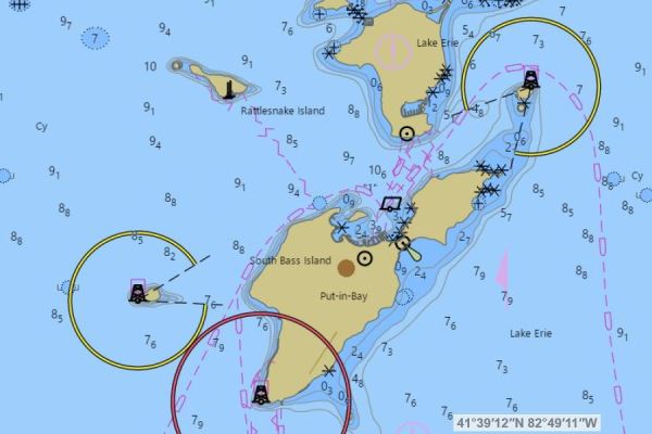
The Raster format chart (the paper ones we have grown accustomed to) are pretty much “what you see is what you get.” Even the small scale, large area charts show any major areas to be avoided. The Electronic Navigational Charts (ENC) requires the user to be more diligent in how the charts are used. For example, the navigator needs to “drill down” to larger scale portions of the chart to obtain significant detail. Personally, I like the Raster chart for longer distance route planning.
Most of the multifunction displays currently offered are using the ENC, or Vector, chart format. But, while there are standards for electronic charting equipment, it is not always the case that the equipment meets these standards. It is important if you change or upgrade the equipment on your boat that you learn the nuances it brings with it.
NOAA is developing a Custom Chart service allowing the user to download a chart of the area to be sailed and to customize it to their needs. It is important though, when using the ENC chart tools, the navigator is aware of the level of detail needed for the area being sailed.
Here is a link to the prototype for this service: https://devgis.charttools.noaa.gov/pod/
An overreliance on digital-only navigation can cause problems. A concern I have as both a navigator and an instructor of navigation is that such overreliance will cause an erosion of the skills that contribute to our safety on the water. Do you remember Team Vestas a few years ago in the Indian Ocean? This may have been a result of not using the navigational tools available to their fullest extent. Then again, I’ve always said to our students there are three types of sailors: those who have run aground, those who are about to, and those who are lying about it… Traditional navigation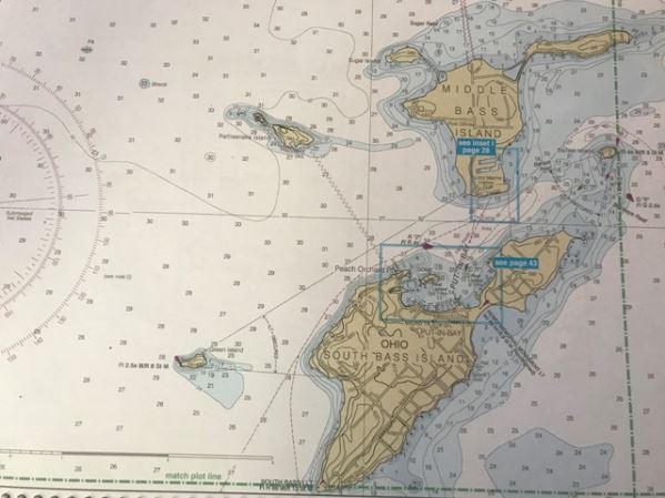 skills are an important asset to any navigator. Knowing how charts and “hands-on” navigation work will make anyone a better navigator in any environment.
The evolution of electronic navigational tools will continue to add to the tools available for our use. GPS is fun, for sure. Whether on a boat, plane or car it has changed how we do things on a daily basis. ENCs will not be going anywhere soon. The International Maritime Organization mandates that all large commercial vessels operating in international waters us ENCs instead of paper charts. In 2016 the USCG started allowing regulated commercial vessels on domestic voyages to use ENCs as well.
Whatever tools and resources you choose to use while navigating, it is important to know how to use them to their fullest extent, to know both their capabilities and limitations and to plan in advance when sailing in new areas around the Great Lakes and anywhere you have the opportunity to sail…also, get good help along the way.